


I. Industry status and needs
Chemical industry is a high-temperature, high-pressure, flammable, explosive and toxic hazardous industry, coupled with the characteristics of large-scale and intensive production units, complex production processes, and tightly coupled production processes, it has a greater danger compared with other industrial sectors. The chemical industry mainly has the following safety pain points and needs:
Pain point 1: difficult to determine the person, chemical plant personnel are numerous and scattered, the actual location of the personnel can not be grasped in real time, the number of people in the workshop can not be accurately known, there is a certain degree of difficulty in management, it is difficult to improve efficiency.
Pain point 2: difficult inspection, the traditional inspection method relies on inspection card inspection, inspection process is easy to miss, wrong inspection. Inspection results can not be monitored and safeguarded.
Pain point 3: difficult to control, chemical plant production environment, high-risk, numerous equipment, for the key areas can not be a full range of supervision, foreign visitors or non-professionals to enter the key areas are very easy to misoperation caused by safety accidents.
Pain point 4: At present, all kinds of supervision and monitoring systems in chemical plants are relatively independent, such as video surveillance system, personnel management system, access control system, etc., and the information is formed into silos, which can't provide emergency management platform and comprehensive decision-making support for managers at all levels, and the management efficiency is low.
Due to the rapid development of Internet and IoT technologies, chemical plants are also facing the road of transformation from digitalization to intelligence. How to combine traditional production data, personnel and other data related to production efficiency and safety, Hainan Shidian Technology has launched a precise personnel positioning management system based on UWB technology, which can provide precise location services to the intelligent platform of the chemical plant to help chemical enterprises to solve the above pain point problems.
II. Overall program structure
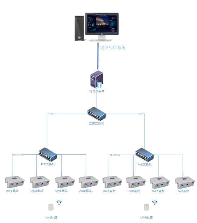
The system includes UWB tag, UWB explosion-proof base station, positioning engine software (C/S architecture) and positioning application system. Positioning tags and positioning base station communicate through UWB pulse signals, positioning base station transmits the received positioning tag data to LS1000 positioning engine for data analysis and processing through 5G network and wired Ethernet, and transmits the processed accurate position to upper layer application through open API interface.
The system components are as follows:
UWB tags: card-type and wristband-type, fixed on top of the person or object to be located, can periodically transmit UWB signals with tag ID information.
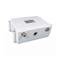
UWB explosion-proof base station: communicates with the positioning tags and transmits information back to the positioning engine algorithm software;
Positioning engine algorithm software: locally deployed, the underlying information data is collected and processed through the algorithm of the positioning engine to get the accurate coordinates of the positioning tag.
Positioning application software: locally deployed or cloud deployed, the application layer software realizes the basic functions such as positioning display, track playback and other functions, as well as the business functions such as electronic fence, intelligent inspection, attendance statistics and video linkage based on the expansion of location data.
III. Related products
Positioning tags and explosion-proof base stations
UWB base station


IV. Program functions
|
function point |
Functional Description |
|
Positioning of personnel and vehicles |
Personnel positioning accuracy of 0.3-1 meters, real-time vehicle speed display. |
|
Historical track search |
It is possible to query the movement track of a certain period of time of a person by specifying the person. |
|
roll call |
You can obtain information about the activities of the people who are in the area by specifying the area. |
|
access control |
Relying on entry beacons to monitor and record information about people entering and leaving the area in real time. |
|
Call for help at the touch of a button |
The card has a built-in SOS button, long press 3S system platform sound and light alarm. |
|
electric fence |
Electronic fence types such as overcrowding, absenteeism, crosstalk, departure, disappearance, etc. can be set. |
|
Inspection Management |
Draw circular, polygonal, and rectangular fenced areas, configure basic information about the inspection area, inspection schedule, and create reports through drawing tools. |
|
In-service statistics |
Real-time statistics on the number of people in each area. |
|
asset location |
Monitor fixed assets by setting up asset location tags. |
|
Alarm record information management |
For different types of alarm information, the icon visualization display is used. |
|
Statistical Queries |
Displays the statistical number of alarms and provides yearly, monthly and same-day query and printing of alarm statistical information. |
|
Location information heat map |
Statistically analyze the positioning data of the distribution of people and vehicles on a particular positioning map, and statistically analyze and draw a heat display map. |
|
position tracking |
Queries a snapshot of the distribution of a person's location information at a given moment in time. |
|
Visitor Management System |
Registers incoming personnel, makes additions, modifications and deletions, and issues and receives cards for incoming personnel. |
|
video link |
Importing video streams into the software platform makes it easy to view the scene in key areas. |
|
Hardware working status management |
Query and locate the working status information of base stations, beacons and other hardware, and display the map location information where the equipment is located, which is convenient for subsequent maintenance and overhaul. |
|
Positioning system addresses support multiple formats |
Tilt photography, Hummingbird Cloud Maps, Goldmap, 3D modeling, 2D maps. |
Content review.