


summarize
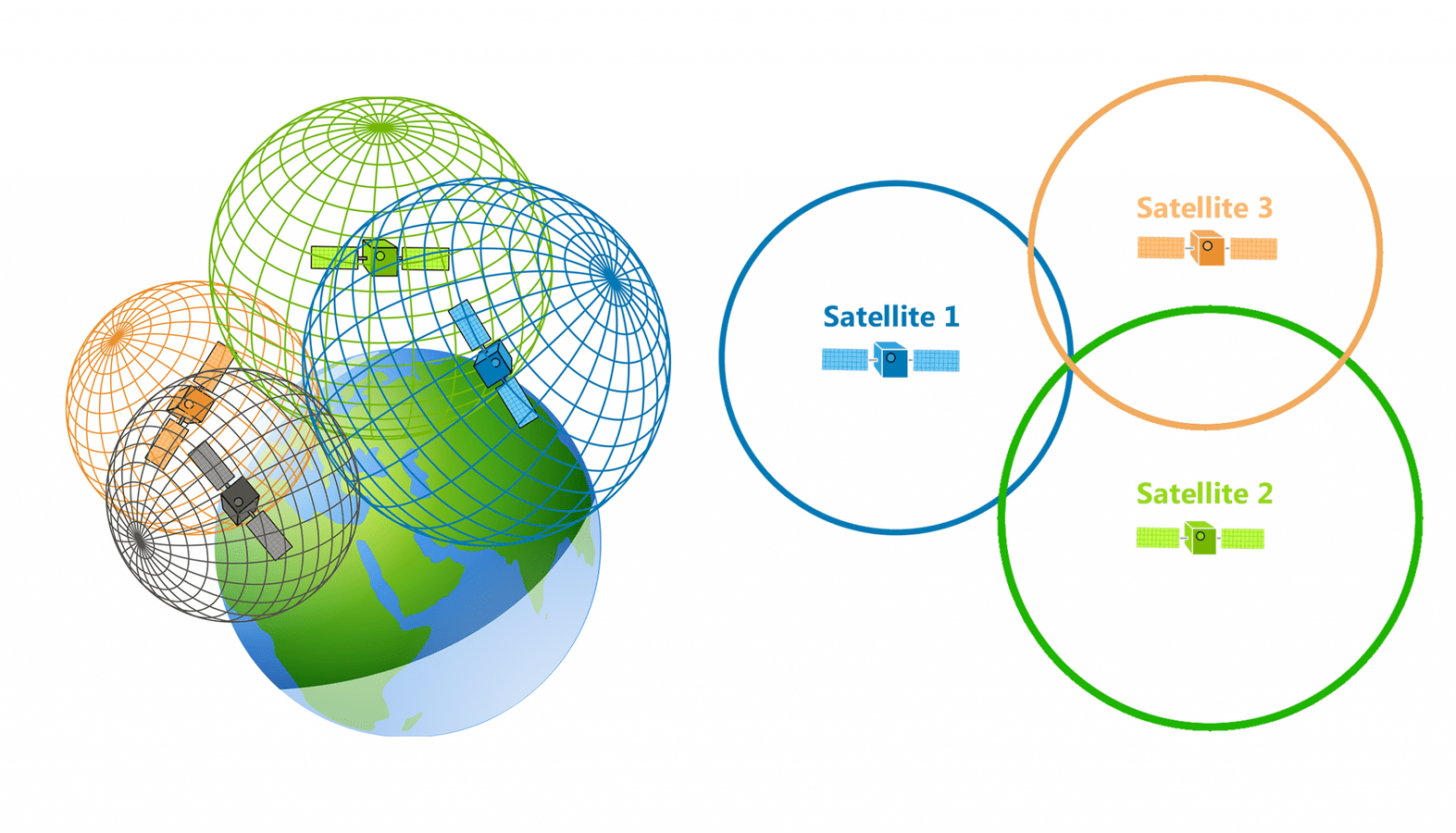
Global Navigation Satellite Systems (GNSS) is the only system that meets the requirements of global coverage and operates independently of locally based equipment. At present, there are four major satellite navigation systems in the world, namely, the U.S. Global positioning system (GPS), the Russian GLONASS, the EU Galileo navigation satellite system (GLONASS), the Chinese Beidou satellite navigation system (Beidou), and the Chinese GLONASS. Global navigation satellite system (GLONASS), the European Union's Galileo navigation satellite system (GLONASS), China's BeiDou navigation satellite system (BDS), and the European Union's Galileo satellite system (GLONASS). navigation satellite system (BDS). We are getting more and more inseparable from it in our daily life, butinterior positioningIt's hard to be covered by navigation satellites, which is why it's so important to get thebluetooth,UWB,RFID,infrared ray,ZigBee, and a variety of other different indoor navigation technologies are booming
Aided Global Navigation Satellite System (AGNSS) is a fully standardized positioning method for outdoor environments. AGNSS receivers use an additional data link to provide satellite imagery, annual calendars, differential corrections and timing information normally obtained directly from geosynchronous satellites. This generally results in a significant improvement in the Global Navigation Satellite System (GNSS) start-up performance, known as Time to First Fix (TTFF).A-GNSS works by providing the necessary data to the device via a wireless network rather than a slow satellite link, essentially "warming up" the receiver for positioning. When applied to GPS, it is referred to as Assisted GPS or Augmented GPS (often abbreviated A-GPS). Other aided navigation systems include Galileo's A-GANSS and Beidou's A-BeiDou.
Principles of global navigation satellite systems
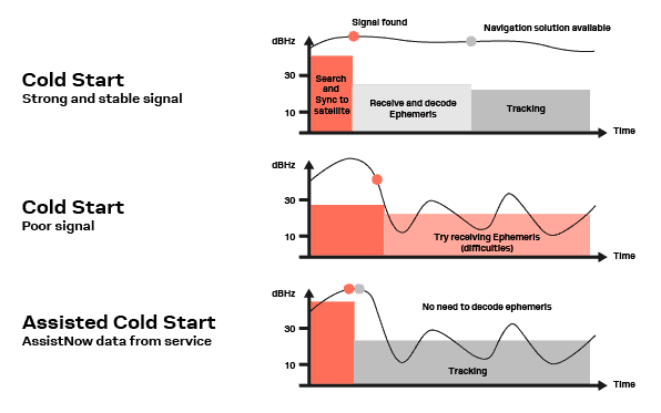
Every GPS device requires orbital data from the satellite in question to calculate its position. Satellite signals have a data rate of only 50 bits per second, so downloading orbital information such as ephemeris and almanacs directly from satellites usually takes a long time, and if the satellite signal is lost in the process of obtaining this information, it is discarded and the stand-alone system has to start from scratch. Under unusually poor signal conditions, such as in urban areas, satellite signals may exhibit multipath propagation, in which the signal skips over structures or is attenuated by meteorological conditions or tree canopies. Some stand-alone GPS navigators used in poor conditions are unable to fix their position due to broken satellite signals and must wait for better satellite reception. Conventional GPS units can take up to 12.5 minutes (the time it takes to download the GPS yearly and ephemeris calendars) to fix the problem and provide the correct position.
In A-GPS, network operators deploy A-GPS servers, which are caching servers for GPS data. These A-GPS servers download orbit information from satellites and store it in a database. A-GPS-enabled devices can connect to these servers and download this information using a mobile network radio bearer (e.g., GSM, CDMA, WCDMA, LTE) or even using other radio bearers (e.g., Wi-Fi or LoRa). In this way the handheld device has very fast access to the relevant satellite data. So in any case where there is no network, all A-GPS will become regular GPS.Assisted GNSS (A-GNSS). Speeds up the signal acquisition process and reduces the time required to achieve a first fix. It accomplishes this by using a faster data connection (usually a wireless network or the Internet) to retrieve satellite data, accurate time and satellite status. With A-GNSS, a GNSS receiver can determine its position in seconds, even under poor signal conditions.
Protocol development
The A-GPS protocol was developed by two different standardization bodies3GPPand the Open Mobile Alliance (OMA) to develop
console protocol
- RRLP - RRLP (Radio Resource Positioning Protocol) defined by 3GPP to support positioning protocols on GSM networks.
- TIA 801 - CDMA2000 series defines this protocol for CDMA 2000 networks.
- RRC Location Protocol - 3GPP defines this protocol as part of the RRC standard for UMTS networks.
- LPP - LPP or LTE Positioning Protocol defined by 3GPP for LTE networks.
client-side protocol
Defined by OMA to support localization protocols in packet-switched networks. Three generations of Secure User Premises Location (SUPL) protocols have been defined, from version 1.0 to 3.0.
signal attenuation
A-GPS is difficult to pinpoint for indoor applications One major reason is the attenuation of the satellite signal. When antenna gain is taken into account, the L1 frequency of GPS satellites (L1 refers to the band of the carrier wave of the navigation satellite signal, which corresponds to the carrier frequency of 1575.42 MHz, and the wireless waves in this band propagate in a straight line within the ionosphere and are little affected by noise).C/A code for(C/A code belongs to the pseudo-random code, firstly, it plays the role of expanding the spectrum of the navigation message signal to improve its anti-jamming ability, and secondly, the C/A code provides a means of measuring the pseudo-ranges, which can determine the code phase of the received signals and calculate the spatial distance from the satellite to the receiver.) is about 500 watts (27 dBW.) The free-space path loss for a 21,000-kilometer satellite reception distance is about 185 dBW (18 orders of magnitude). Therefore, a signal power of 27 dBW-185 dBW =-158 dbw =-128 dBM is expected at the Earth's surface. The relevant quantity for signal acquisition is the receiver-specified signal-to-noise ratio (SNR - the ratio between signal power and noise power ), which depends not only on the received signal power but also on the receiver amplifier.
In addition to free-space path loss, building materials cause additional attenuation of satellite radio signals in indoor environments, with the attenuation coefficient depending mainly on the electrical properties of the material, such as the dielectric coefficient. Signals penetrating reinforced concrete walls result in 20 dB to 30 dB (100 to 1,000 times) attenuation compared to outdoor signal amplitude. Loss factors for various materials, while wood homes have moderate attenuation of 5dB to 15dB, typical brick or concrete buildings have losses of 30dB to 30dB; in underground parking lots and tunnels, satellite signals have been virtually undetectable for GNSS receiver loss factors > 30dB.
Higher transmitter power would improve signal strength and mitigate the effects on satellites actually in service. In addition to the attenuation of GNSS signals, the subject of indoor signal reception is further complicated by phenomena such as reflection, diffraction or scattering that can cause radio signals to enter buildings, and multipath reception that results in individual time-shift measurements degrading the quality of the received signals and leading to less reliable positioning.
Assisted GNSS Indoor Positioning
One of the main difficulties to overcome with indoor positioning using GPS is how to determine the user's position indoors/under cloud exposure. While assisted GPS mitigates this to some extent, GPS triangulation is still unclear inside buildings, so a system must be created to overcome this. Using other techniques with AGNSS for indoor positioning is a more effective and convenient way, for example the technical application of QR (Quick-Response) QR codes can be an ideal method, there is a bulletin board inside each building and floor of a building or campus, mapping the building can take advantage of this and placing a poster with a QR code which contains the building/floor GPS coordinates, and when scanned by a smartphone, it will open the mapping application and show your location on the building map. This application approach has already been tried on some campuses.
Content review.